Questions & Answers
- Why is Lurline Street being upgraded?
Lurline Street links Katoomba Town Centre to Echo Point and the Three Sisters. As such it is the gateway to the Blue Mountains most famous attraction visited by around three million people a year.
It is also an important local thoroughfare to shops, services, Katoomba Public, St Canices Primary and Katoomba High School. The street is not as steep as alternative routes such as Katoomba Street, and is therefore the most popular route for walking and cycling.
The project to restore Lurline Street as a tree-lined boulevard was community initiated and continues to be community-driven. In 2009, following resident advocacy, a feasibility study by Council for street planting in Lurline Street recommended that the above ground electrical powerlines be relocated underground to allow for the planting of large trees. It also recommended that a full upgrade of street infrastructure be part of the works. These recommendations were supported by an independent study in 2015.
- What type of trees will be planted?
Liquidambar styraciflua, a medium to large deciduous tree, will be planted as the main tree species.
- Why was this particular tree species selected?
The final choice was from a short list drawn up by the City Council’s and Treeline Lurline’s arborists and landscapers. It was based on detailed considerations of criteria for urban street trees and the project’s vision in the grant application. Key criteria include:
* large trees of uniform shape to create a grand boulevard for locals and visitors enjoying a walk, cycle or drive between Katoomba town centre and the Three Sisters at Echo Point;
* striking seasonal colour with cooling shade in summer and light on the street in winter;
* proven examples of the species flourishing in the Upper Mountains’ climate and urban conditions;
* fire-retardancy;
* availability of advanced, consistent, high-quality stock.
The tree species’ popularity, sustainable maintenance and capacity to make the most of the optimum conditions were also considerations.
- What are the expected maximum heights of the trees? How long will this take?
15 to 20 metres in the next 20 to 25 years.
- Will native species be planted?
The Liquidambars will be complemented by street gardens at all intersections planted with mostly native species and cultivars that have also been successful in our cool climate urban environment.
- Will the trees be in the road or footpath?
The trees will be in small garden beds on either side of the road in the parking lanes.
- How many trees will be planted?
For Block One from Waratah to Merriwa, 21 Liquidambars will be planted with an initial height of around 4 to 5 metres.
- Will the trees reduce parking?
Careful rationalisation of the free-form parking into formal bays for the first block from Waratah to Merriwa has resulted in the loss of one parking space during the day. The new timed bus-stop will increase parking at night. Careful consideration to minimise loss of parking spaces will continue for future stages down the street.
- Will the trees roots or branches harm infrastructure on Lurline Street?
The new tree planting has been located between on-street parking bays. Underneath the parking bays a continuous soil trench will ensure sufficient soil volumes for good tree health. Investigations have already confirmed more than adequate soil depth above the bedrock.
The parking bays will be paved with a porous surface to filter water to the trees and improve stormwater run-off.
Honeycomb-like structures, called stratavault cells, installed under the surface of the parking bays will sustain an uncompacted soil substrate to encourage root growth while also providing structural support for the road surface.
Longitudinal root barriers will prevent root growth encroaching under the road carriageway and footpath.
The careful selection of high quality advanced tree stock by our consulting arborists and landscape architect has ensured we start with healthy stock. Formative pruning in the early years will further strengthen and shape the trees to prevent weak limbs and breakage.
These measures will benefit tree growth and mitigate roots and branches encroaching on infrastructure or traffic.
- How will the trees get water?
The trees will be in small garden beds. The parking bays beside them will be paved with a porous asphalt that allows rainwater to filter through into the soil.
The trees will be watered by Council during their early years if there is insufficient rain.
- Will the trees create a fire corridor?
No. On the contrary, it is intended that the trees and gardens will form a fire shelter belt to help reduce radiant heat, winds and ember attacks generated by bushfire that are the main threat to properties. Combined with the water sensitive urban design and stratavault cells that will improve moisture retention in the trees and soil, this will reduce bushfire risk to properties. Undergrounding the power lines further reduces the risk of fire.
- Will the improvements be undertaken all the way down Lurline Street?
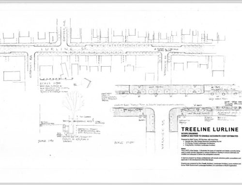
The Treeline Lurline project extends 1.6 kilometres along Lurline Street from the junction with Waratah Street at the bottom of the Katoomba town centre, where power is already underground, to Forster Road on the approach to Echo Point from where power is also undergrounded.
A Federal Government grant has funded the concept designs for all seven blocks. Detailed design and construction of the first section from Waratah to Merriwa Streets is also covered by this grant. Further funding will be sought to complete the other six blocks.
The completion of the first block of renewal of urban infrastructure to a high standard will be an exemplar and hopefully a catalyst for future funding to continue the grand boulevard all the way to Echo Point.
- Why didn’t the project include the first block of Lurline Street from Gang Gang?
The block from Gang Gang to Waratah Street is not included in the project because the steep topography will require very different treatment. It will need to be a stand-alone project.
The project is also intended to be a central link in the walk that starts at the top of town at the Railway Station, progresses down Katoomba Street through the Central Business District for one block, turns into Waratah Street for one block and then progresses down Lurline Street and Echo Point Road to Echo Point. This is already the preferred pedestrian route.
- What is being done to make the street safer?
A new pedestrian crossing will be installed between Waratah and Merriwa Streets. This will provide a safe crossing, particularly for school children and their carers, walking to and from the Katoomba Public, St Canices Primary and Katoomba High School. The crossing will also provide traffic calming to the street and help to reduce traffic speeds.
An additional pedestrian crossing has been proposed at Kurrawan Road, which is a high use area for Katoomba High School. This will be further investigated at a later date when funding becomes available for the rest of the works along the street.
Infrastructure for a dedicated cycleway next to the footpath on each side of the road is also part of the design for the whole street, see below.
- Will there be a cycleway?
Stage One includes kerb re-alignment and aggregate paving for a dedicated one-way cycleway on each side of the street beside the footpath. However, the cycleway and footpath will initially be signed as a wide ‘shared path’ for walkers and wheelers. This is because the first stage of the works only covers a few hundred meters of Lurline Street. This is not long enough to be practical as a cycle path.
When funding is secured to deliver the remaining six blocks of the project, the dedicated cycleway will be formalised running all the way down Lurline Street as an important part of the project vision.
- What pavement material will be used?
The pavement materials will be varied: porous asphalt for the parking bays, decorative asphalt (yes, it exists) for the footpath, aggregate in the same style as Echo Point paving for the cycleway and feature paving at junctions with locally themed designs.
- Will the overhead poles and wires be removed on Lurline Street?
The electrical infrastructure is currently being relocated underground on Lurline Street between Waratah and Merriwa Streets (March-May 2024). Designs for the powerlines to be undergrounded from Merriwa to Forster have been completed. Further funding is required to carry out these works.
The power is already undergrounded in the town centre up Katoomba Street. It is also undergrounded from Forster Road to Echo Point.
- What will happen to the street lights on the power poles?
New streetlights have been designed to meet current standards and will be installed in conjunction with the power undergrounding from Waratah to Merriwa Streets. This will improve street lighting for the block.
- Will accessibility along Lurline Street be improved?
The existing slope along the seven blocks of the project is a relatively easy grade which explains why the street is already the most walked and cycled route between the town and escarpment.
Accessibility will be improved by the new paved surfaces and the widened space available for pedestrians and cyclists. It will also be improved by removing obstacles from the street such as power poles and redundant signage.
Seating and other street furniture will facilitate people of all ages and abilities resting along the way.
- Will there be heritage interpretation?
Yes. Council is currently working on a whole-of-Katoomba heritage walk that would include both Katoomba Street and Lurline with wayfinding signage to other important sites such as the Gully.
Council’s heritage staff are working with the Treeline Lurline’s Lead Designer and its Arts & Heritage working group to develop specific interpretative elements for Lurline Street’s first block. Street furniture and feature paving will also provide opportunity for designs that reference local heritage themes.
- What works have been undertaken to date?
Numerous investigations have been undertaken including a site survey, detailed underground service investigations, site soil tests, traffic and pedestrian counts, mapping of Council’s stormwater system and geotechnical assessment.
The electrical designs for undergrounding power in Block One have been completed and approved by Endeavour Energy. The construction has been contracted and began on 4 March 2024. The works, including installation of new lighting, will be completed by late May or early June 2024.
Concept designs for undergrounding power and new lighting have also been completed for the other six blocks of the project.
Draft designs for civil works including tree-planting, cycleway, footpath, new paving and street furniture were publicly exhibited last November and have since been finalised. They have received planning approvals. Tenders for these civil works for Block One opened on 9 April and closed on 30 April with the intention that the work will start in June 2024.
- Who is paying for the project?
The Treeline Lurline Project was initiated and developed by Katoomba Chamber of Commerce & Community and its Treeline Lurline Steering Committee of local residents, businesses and community groups. The project has developed from a 2009 feasibility study undertaken by the Council for street tree planting in Lurline Street. It is consistent with the 2023 Katoomba Master Plan and is an important element of it.
Stage One has been funded by the Australian Federal Government’s Black Summer Bushfire Recovery Program with a $4,004,275 grant to Katoomba Chamber of Commerce & Community.
Bendigo Community Bank Katoomba is a sponsor and community partner. The National Trust Blue Mountains Branch and Blue Mountains Tourism are community partners.
Katoomba Chamber of Commerce & Community continues to provide extensive volunteer support to most aspects of the project through its Treeline Lurline Steering Committee and Project Control Group delegates.
Blue Mountains City Council is also providing in-kind contributions with assistance on survey, design, planning and project management.
- Who is managing the project?
Blue Mountains City Council is managing the project as the government authority responsible for local roads. The Katoomba Chamber of Commerce & Community manages the funds it has received for Stage One of the project from the Federal Government Grant, Bendigo Community Bank Katoomba sponsorship and other smaller contributions.
There is a Project Manager contracted by the Council who convenes a joint Project Control Group with delegates from the Council and Chamber.
The volunteer Steering Committee that initiated the project is convened by the Katoomba Chamber and meets monthly to advise and support the project and monitor progress for the grant reporting.
- Who will maintain the new street infrastructure, trees and gardens?
Council will continue to be responsible for the ongoing maintenance of the road and footpaths, street furniture, trees and garden beds.
Endeavour Energy will be responsible for ongoing maintenance of the underground electrical cables and the street lights.
A consulting arborist will care for the street trees in their early years, including their formative pruning. The Katoomba Chamber has committed to securing funds for this.
- Will the Council manage the autumn leaves?
Yes.
Treeline Lurline will also work with Council to establish local composting of the leaves for use on the Lurline public gardens. A current example of this is Compost Corner set up by the garden volunteers of the Leura Village Association. There are over forty trees in the gardens of Leura village centre including 40-year-old Cherries and Crab Apples, a Golden Elm and two 120-year-old Plane Trees. Clippings and autumn leaves from the trees and shrubs are composted in a dedicated corner of the Council car park and returned to the gardens as mulch.
- Who was consulted about the project?
Since 2019 there have been ongoing opportunities for public feedback and ideas.
Jan 2019–Present
Treeline Lurline Facebook page established. The page allows public posts and comments and links to the Treeline Lurline website and the Council web page for the project.
06 Feb 2019
Treeline Lurline public forum, hosted by the Katoomba Chamber of Commerce & Community and its new Treeline Lurline working group at Carrington Hotel.
Event promoted by social media, Katoomba Chamber newsletter, letterboxing Lurline Street and surrounds, Lurline street stalls.
14 Feb 2019
Meet the Candidates public forum for the State Election hosted by Katoomba Chamber. Treeline Lurline is a key item of discussion. The project receives support from all election candidates.
Feb 2019–Present
Updates and discussion at monthly meetings of Katoomba Chamber of Commerce & Community. (Membership of the Chamber is open to Blue Mountains residents and businesses.)
Nov 2019
Public Exhibition for Blue Mountains City Council Draft Local Strategic Planning Statement. The LSPS (approved in March 2020) includes as Priority Action 7.8 an upgrade of the Lurline streetscape.
Opportunity to engage is promoted by Council forums, social media, website and Blue Mountains Gazette articles and advertising; Katoomba Chamber meetings.
2022
Treeline Lurline power point presentations with Q&A
-
- Rotary Club of Upper Blue Mountains
- Rotary Club of Central Blue Mountains
- Katoomba Chamber of Commerce & Community
Oct–Dec 2022
Public exhibition of Blue Mountains City Council’s Draft Katoomba Master Plan .
Lurline Street is the ‘spine’ for all Place Vitality Criteria and proposals. The Treeline Lurline project is outlined across two pages and receives the most positive submissions of any proposal in the Master Plan.
Opportunity to engage is promoted by Council and Treeline Lurline websites and social media; Council community forums, rates notices/ Community Snapshot; Katoomba Chamber newsletter and meetings; Blue Mountains Gazette articles and advertisements.
Feb 2023
First Nations Afternoon Tea hosted by Aunty Carol Cooper
Invitation extended through hand delivered letters, Council’s First Nations Officers and Blue Mountains Aboriginal Culture & Resource Centre.
Jun–Jul 2023
Public exhibition for submissions on the Treeline Lurline project.
Opportunity to engage is promoted by Council and Treeline Lurline websites and social media; Council rates notices/ Community Snapshot; Katoomba Chamber newsletter and meetings; letterboxing Lurline Street and surrounds; Blue Mountains Gazette article and advertisement.
Nov 2023
Council Public exhibition of Treeline Lurline Draft Designs.
23 Nov 2023
Drop-in information session, Alex Allen Park.
Opportunity to engage is promoted by Council and Treeline Lurline websites and social media; Council rates notices/ Community Snapshot; Katoomba Chamber newsletter and meetings; letterboxing Lurline Street and surrounds; Blue Mountains Gazette article and advertisement.
In addition, Councillors, individuals and community groups have been able to publicly speak about the project at any Council meeting since October 2009 where it is an agenda item or part of an item. This opportunity has been taken up by both councillors and members of the public.

Watercolour impression of the Treeline Lurline vision by David Wardman.
Q.1. Lurline Street from Waratah to Echo Point is planned as the South Katoomba spine for Electrical Vehicle (EV) shuttles and Active Transport (walking and wheeling). Fig. 11, Katoomba Master Plan, Blue Mountains City Council, 2023.
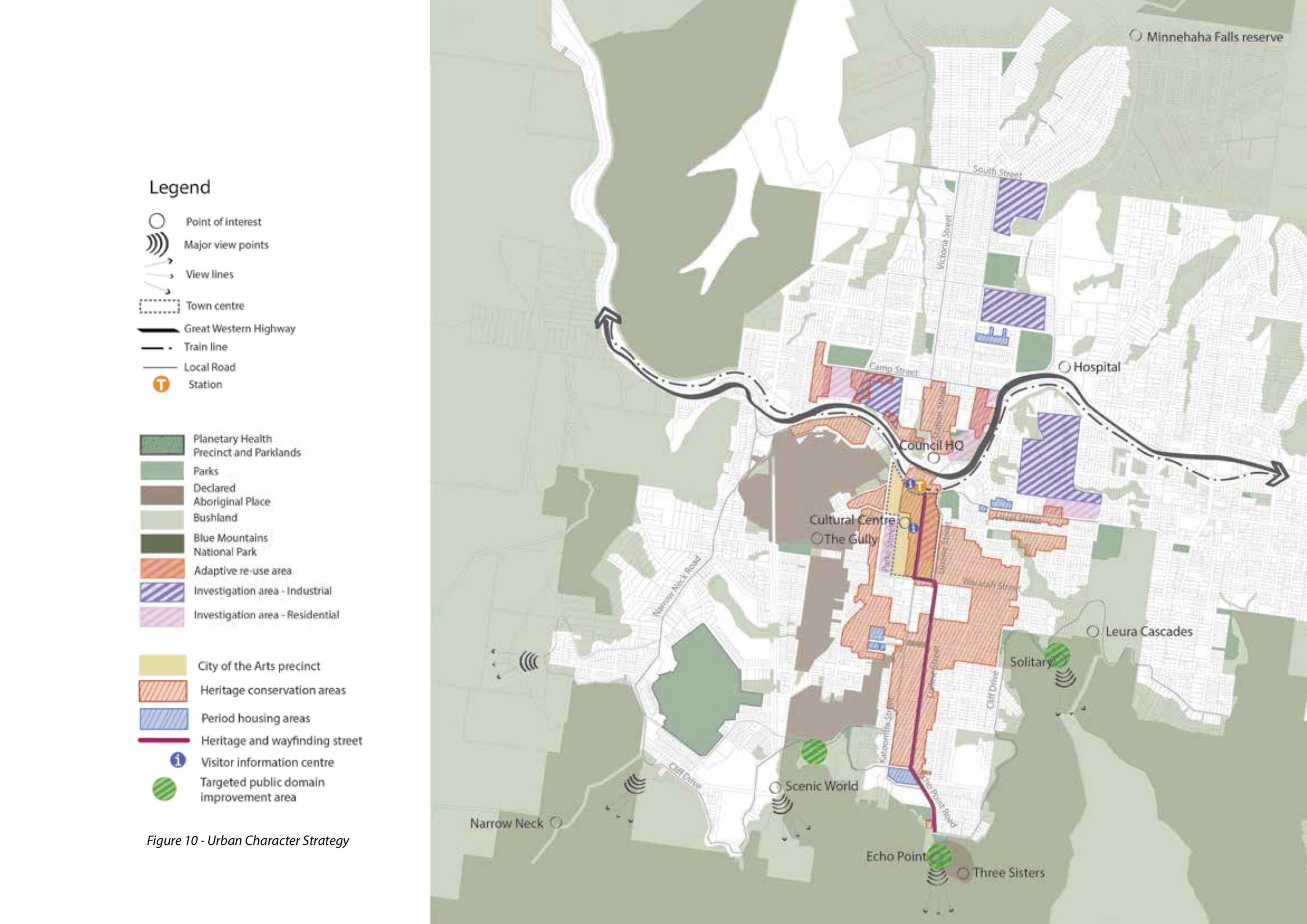
Q.1. Plan for Heritage and Wayfinding route is down Katoomba Street for one block, into Waratah, then down Lurline to the Three Sisters and National Park. Fig. 10 ‘Urban Character Strategy’, Katoomba Master Plan, Blue Mountains City Council.

Q.2-3. Liquidambars approved by consulting arborists for purchase for Treeline Lurline project.

Q.4. Liquidambars, autumn 2024, Wentworth Street, Blackheath, planted in 1930s. Photo by Michael Small.

Q.9. Stratavault cells being installed around a tree’s roots for another streetscaping project.

Q.14. Design for pedestrian crossing in Block One outside the RSL Club building.

Q.15. Artist’s impression of cycleway between the trees/ parking lane and footpath on Lurline Street.


Q.21. Undergrounding works, from the top: cutting the pavement on 4 March, conduits for the cables to be laid in the pavement trenches, trenching work on the western side of the street.

Q.25. Leura Village Association volunteer, Christine Cuneo, raking leaves in Leura Mall for composting.

Q.25. Leura Village Association volunteers, Jenny and Doug Morris, harvest compost of Leura Mall leaves and clippings.